CALL US: 0481 111 119

A DIVISION OF
AUSTRALIAN AERIAL IMAGERY PTY
Est 2014
Licensed Sydney Lidar Drone Operator & Service Provider
Our website uses HTML for interactivity, but security measures can block it. If you encounter issues like broken links, please use a personal computer for full functionality.
DRONE LiDAR SERVICE PROVIDER
DRONE & VEHICLE LiDAR SCANNING
We elaborate on some of LiDAR's benefits in contrast to photogrammetry, including superior precision, obstacle-penetrating capabilities, efficiency in data collection, adaptability to low-light conditions, and versatile applications.
Benefits of Using Drone LiDAR vs. Photogrammetry for Surveying:
-
Accuracy and Precision:
-
Drone LiDAR offers superior accuracy as it directly measures distances with laser pulses, resulting in precise 3D point clouds. Photogrammetry relies on image matching, which can introduce errors, especially in complex terrains.
-
-
Penetration Through Obstacles:
-
LiDAR can penetrate vegetation and other obstacles, providing an accurate representation of the ground surface. Photogrammetry may struggle when capturing obscured or hidden features.
-
-
Speed and Efficiency:
-
Drone LiDAR is faster in data acquisition over large areas due to its direct scanning method. Photogrammetry may require multiple flights and extensive processing time to achieve similar coverage.
-
-
Low-Light and Nighttime Operation:
-
LiDAR systems are active sensors and can operate effectively in low-light conditions or at night. This is advantageous for surveying near airports and roads when there is minimal traffic or during nighttime hours when airport operations are halted.
-
-
Data Density:
-
LiDAR generates dense point clouds with precise measurements, ideal for applications requiring high-detail data, such as topographic mapping, infrastructure inspection, or archaeological site documentation. Photogrammetry may produce less dense point clouds.
-
-
Consistency Across Lighting Conditions:
-
LiDAR measurements are not affected by changing sunlight or weather conditions, ensuring consistent data quality. Photogrammetry can be sensitive to variations in lighting and atmospheric conditions.
-
Drone LiDAR Near Airports and Roads at Night:
Using drone LiDAR for surveys near airports and roads at night offers several key benefits:
-
Safety and Reduced Interference:
-
Nighttime LiDAR operations can be conducted without interfering with daytime airport or road activities, enhancing safety and minimizing disruptions to traffic.
-
-
Enhanced Data Collection Opportunities:
-
During nighttime hours, when airports are less active and roads have minimal traffic, surveyors have an extended window of opportunity to collect data with minimal interruption.
-
-
Emergency Response and Maintenance:
-
LiDAR-equipped drones can quickly assess and monitor airport runways, taxiways, and road infrastructure during nighttime hours. This is particularly valuable for emergency response and maintenance operations.
-
-
Improved Data Quality:
-
Low-light conditions can actually benefit LiDAR data collection by reducing potential glare and shadows, leading to enhanced data quality.
-
In summary, drone LiDAR offers superior surveying capabilities compared to photogrammetry, particularly in terms of accuracy, penetration, and efficiency. Using LiDAR-equipped drones for nighttime surveying near airports and roads is a practical and safe approach, taking advantage of reduced interference and extended data collection opportunities. This combination of technology and timing enhances the effectiveness of surveying tasks in these critical areas.
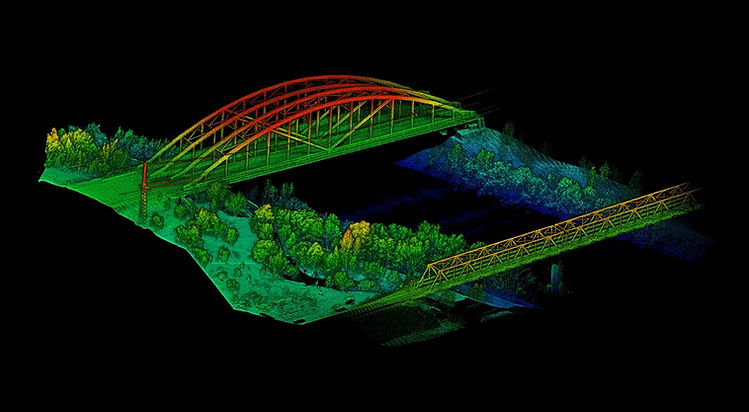
Below: One of our long ongoing projects.

Drones and vehicles equipped with LiDAR technology offer invaluable advantages compared to photogrammetry in many scenarios. However, it's important to recognize that each method has its unique strengths, and one is not inherently superior to the other. The choice between LiDAR and photogrammetry depends on the specific requirements of your project.
At Lidar Drone Australia, we understand the significance of selecting the right technology for your unique needs. We offer expert guidance and tailored solutions to ensure your project's success. Contact us today to determine the best approach for your particular project. Your success is our priority.