
In recent years, LiDAR (Light Detection and Ranging) technology has emerged as a game-changer in various industries, including forestry and environmental monitoring. When combined with the agility and flexibility of drones, LiDAR technology has opened up new horizons for conducting accurate and efficient tree surveys. Whether the survey area spans one hectare or hundreds of hectares, LiDAR drones are transforming the way we gather valuable data about our forests and vegetation. In this blog post, we'll explore the numerous benefits of using LiDAR drones for tree surveys and delve into the types of survey data that can be generated through post-processing LiDAR software.
Benefits of Surveying Trees with LiDAR Drones
Highly Accurate Data Collection: LiDAR technology uses laser pulses to measure distances and create detailed 3D point clouds. When mounted on drones, this technology provides unparalleled accuracy in measuring tree heights, canopy structures, and even the ground terrain beneath the canopy.
Efficient Coverage: LiDAR drones can cover large survey areas quickly and efficiently. This speed and coverage capability are especially advantageous for surveying expansive forests or areas that are difficult to access by traditional means.
Detailed Information: The 3D point cloud data generated by LiDAR drones captures a wealth of information about individual trees, including their size, shape, density, and spatial distribution. This level of detail is invaluable for assessing forest health and planning management strategies.
Minimized Environmental Impact: Traditional ground-based tree surveys can be invasive and disruptive to ecosystems. LiDAR drones, on the other hand, minimize the environmental impact by surveying from above, avoiding damage to the forest floor and minimizing disturbances to wildlife.
Safety and Accessibility: Conducting tree surveys in dense or remote forests can be hazardous for field personnel. LiDAR drones eliminate these safety concerns by remotely collecting data, reducing the need for personnel to enter challenging terrain.
Types of Survey Data Generated by LiDAR Drones
Tree Height and Canopy Structure: LiDAR drones can accurately measure the height of individual trees and assess the overall canopy structure. This data is crucial for estimating biomass, calculating carbon sequestration, and understanding forest growth patterns.
Tree Density and Spatial Distribution: LiDAR technology can provide insights into tree density and spatial distribution within a surveyed area. This information helps forest managers make informed decisions about thinning, harvesting, or reforestation efforts.
Terrain Modeling: Beyond tree-related data, LiDAR drones also capture the terrain beneath the canopy. This terrain modeling can aid in watershed management, flood modeling, and other land-use planning tasks.
Forest Health Assessment: LiDAR data can identify signs of stress or disease in trees by detecting changes in canopy height or density. Early detection allows for targeted interventions to protect the forest's health.
Wildlife Habitat Analysis: The detailed 3D data collected by LiDAR drones can help identify wildlife habitats within a forested area. Conservationists can use this information to develop strategies for protecting and conserving these habitats.
Fire Risk Assessment: LiDAR data can be used to assess the risk of forest fires by analyzing factors such as tree spacing, canopy density, and terrain characteristics. This information aids in developing fire prevention and management plans.
Post-Processing LiDAR Software
To fully harness the potential of LiDAR drone data, specialized software is used for post-processing and analysis. Some of the critical functions that these software packages offer include:
Point Cloud Filtering: LiDAR data often contains noise or unwanted points. Post-processing software allows for the removal of such points, resulting in a cleaner and more accurate dataset.
Classification: LiDAR software can classify points into different categories, such as ground, vegetation, and buildings. This classification is essential for generating meaningful information about trees and their surroundings.
Tree Segmentation: The software can identify individual trees within the point cloud, enabling the measurement of tree height, diameter, and other attributes.
Vegetation Analysis: LiDAR software can analyze vegetation density and distribution, providing valuable insights into forest health and composition.
Terrain Modeling: Software tools can create detailed digital elevation models (DEMs) and digital surface models (DSMs) from LiDAR data, aiding in terrain analysis and land management.
Visualization: LiDAR software often includes visualization tools that allow users to explore the data in 3D, making it easier to interpret and communicate findings.
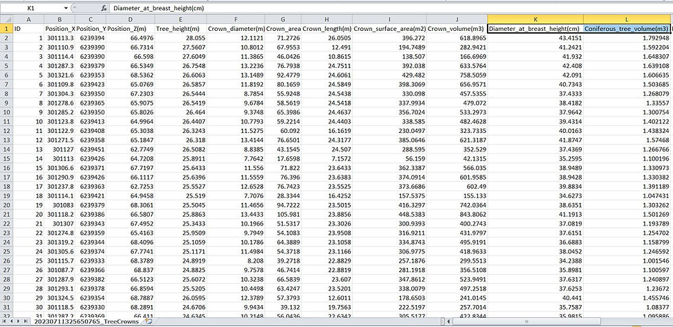
Below: Individual tree data obtained from a LiDAR drone scan.

Below: Data that can be collected from a LiDAR drone tree survey.

In conclusion, LiDAR drones are revolutionizing tree surveys by offering a combination of accuracy, efficiency, and environmental responsibility. Whether surveying a small hectare or an expansive forest, these unmanned aerial systems equipped with LiDAR technology are providing invaluable insights into forest ecosystems. The rich and detailed data they capture, when processed using specialized software, supports a wide range of applications, from forest management and conservation to land-use planning and disaster risk assessment. As technology continues to advance, we can expect LiDAR drones to play an increasingly prominent role in preserving our forests and understanding their ecological significance.
Comments